


Connecticut’s Mother’s Day weekend starts on a wet note, with clouds increasing tonight and showers expected by daybreak Saturday. The bigger problem arrives Saturday, when a First Alert Weather Day is in effect because rain and cool, breezy conditions are expected to disrupt outdoor plans across the state.
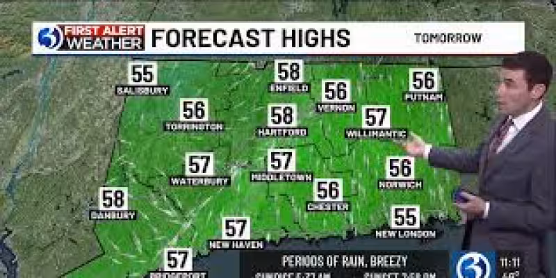
Saturday should be breezy and cool, with temperatures running 10 to 15 degrees below normal and periods of rain lasting from the morning through sunset. Rain is expected to become more substantial late in the afternoon and into the evening, and some rumbles of thunder cannot be ruled out. Even so, severe weather is not a concern. Forecasters are calling for 0.5 to 1.0 inches of rain, with locally higher amounts possible, but the rain should fall over a 12- to 18-hour window, limiting any flooding threat.
That timing is what makes Saturday the main impact day. By spreading the rain out through much of the day, the system is expected to soak plans more than it overwhelms the ground. For people hoping to salvage a weekend outing, the better news comes on Mother’s Day itself, when most of the day is expected to be dry and only isolated afternoon showers are possible. Temperatures should climb into the upper 60s and lower 70s, making it the warmest day of the next seven.
The improvement does not last long. The chance for rain increases again Sunday night, and showers are expected to linger through Monday morning before cloudiness gives way to at least partial clearing Monday afternoon. Monday is expected to be unseasonably cool, with temperatures only reaching the 50s. Tuesday should turn partly to mostly sunny, then Wednesday begins dry before showers arrive late and continue into Thursday. Temperatures are expected to stay below average through the latter part of the week.
The forecast comes after a stretch of swings that has already pushed Connecticut from one weather extreme to another. Hartford Area temperatures bottomed out at 27 on Tuesday, April 21, tying the record low from 1961, while Bridgeport fell to 33, still above its record low of 29 from 1956. Just days earlier, temperatures nearly reached record levels on Thursday, April 16, when Hartford hit 90 at Bradley International Airport, falling short of the record 92, and Bridgeport reached 83, two degrees shy of its record of 85.
Earlier this spring also delivered a quick run of warmth. Bridgeport tied its record high of 64 on Monday, March 9, while Hartford reached 70 that same day for the first time since October 19th. Hartford then climbed to 79 on Tuesday, March 10, breaking the March 10 record high of 72 set in 2016, before posting an official high of 74 on Wednesday, March 11, just one degree shy of the 1977 record of 75.
And before that came a winter that had already loaded the atmosphere with reminders of what a Connecticut cold season can do. Meteorological winter ran from 12.01 to 02.28, with an average temperature of 25.6 degrees, 4.1 degrees below average. During that period, 52.3 inches of snow fell statewide, 13.2 inches more than normal, while Bridgeport picked up 55.9 inches, 31.2 inches above average. Three National Weather Service sites in Connecticut — Bridgeport, New Haven and Groton/New London — met blizzard criteria, defined by visibility of 1/4 mile or less and wind speeds of 35 mph or higher.
For now, the question for the weekend is simpler than the season-long weather pattern: whether families can get through Saturday’s washout before Mother’s Day turns more cooperative. The forecast says they can, and that Sunday should be the better day to be outside.